 OrthoGraph Survey 2.0
OrthoGraph Survey is a PDA/phone based professional software for building surveys. It supports floor plan survey by facilitating digital floor plan sketching and instant creation of AutoCAD compatible drawings on-site. It supports Leica Disto D3a/D8.
Last update
10 Feb. 2011
Licence
Free to try |
$1,161.00
OS Support
Windows
Downloads
Total: 736 | Last week: 2
Ranking
#295 in
3D Modeling & CAD
Publisher
Orthograph Ltd.
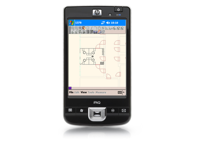
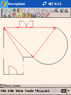
Screenshots of OrthoGraph Survey
OrthoGraph Survey Publisher's Description
OrthoGraph Survey is a professional solution for building surveys (i.e. floor plan, elevation and cross-section surveys). The software is built for appraisers, insurance inspectors, architects, real-estate agencies, CAFM companies, flooring installers and anyone who needs digitized drawings or to calculate the area and perimeter of a floor plan even on-site.
OrthoGraph Survey supports floor plan sketching and measurement using a PDA or Windows Mobile Phone. The module shows measured drawings in real time and facilitates the creation of AutoCAD/ArchiCAD/Google SketchUp compatible drawings on site. Measured rooms or graphical parts are ordered into a structural view so that users obtain a clear overview of what they are measuring. Floating islands or ghost layers help users attach rooms to one another and display only the focused information that is relevant to the task at hand. Features also include support for Leica Disto D3a BT and D8, which can control automatic measurement tasks via Bluetooth. Default output formats are 2D and 3D DWG, SKP and PDF, but other formats are also supported. The survey software can be customized through a desktop-based ProjectManager component.
Product features:
* PDA application, including high resolution PDAs
* Handling spaces in a hierarchic structure
* Storing of up to 160,000 objects
* Preparing sketches of ground-plans right on the site
* Automated graphic assessment
* Fast graphic assessment
* Showing the measured drawing as you work on the spot
* Connecting places - "Floating Islands" function
* Handling "Ghost Layers" - display of drawn areas in the background
* Team-work for supporting large projects
* Support of the Leica Disto D3a BT/ D8 laser distance meter
* Easy customization through the desktop ProjectManager component
* PDF Reports
OrthoGraph Survey provides with its speed and easiness the best support for creating floor plans and area calculation on-site.
What's New in Version 2.0 of OrthoGraph Survey
-Native ArchiCAD import Add-On,
-Support of high resolution PDAs,
-JPG, PDF, GIF, and other formats are supported,
-Support of .NET2 framework,
-Handling of up to 160,000 objects,
-Leica Disto D8 and D3a BT distance meter supported,
-No need for a PDA to try OrthoGraph,
-ArchiFM Integration.
-Support of high resolution PDAs,
-JPG, PDF, GIF, and other formats are supported,
-Support of .NET2 framework,
-Handling of up to 160,000 objects,
-Leica Disto D8 and D3a BT distance meter supported,
-No need for a PDA to try OrthoGraph,
-ArchiFM Integration.
Look for Similar Items by Category
Feedback
- If you need help or have a question, contact us
- Would you like to update this product info?
- Is there any feedback you would like to provide? Click here
Popular Downloads
-
 Macromedia Flash 8
8.0
Macromedia Flash 8
8.0
-
 Kundli
4.5
Kundli
4.5
-
 My Talking Tom
1.0
My Talking Tom
1.0
- FastSum 1.9
-
 FastSum Standard Edition
1.6
FastSum Standard Edition
1.6
-
 Cool Edit Pro
2.1.3097.0
Cool Edit Pro
2.1.3097.0
-
 Cheat Engine
6.8.1
Cheat Engine
6.8.1
-
 Hill Climb Racing
1.0
Hill Climb Racing
1.0
-
 Windows XP Service Pack 3
Build...
Windows XP Service Pack 3
Build...
-
 C-Free
5.0
C-Free
5.0
-
 Horizon
2.9.0.0
Horizon
2.9.0.0
-
 Tom VPN
2.2.8
Tom VPN
2.2.8
- HP LaserJet 1100 Printer Drivers 4.3.2.5
-
 Mozilla Firefox
108.0...
Mozilla Firefox
108.0...
- HP WLAN 802.11a/b/g W500 2.4.1.30
-
 Iggle Pop
1.0
Iggle Pop
1.0
- HP Deskjet 5400 Series (DOT4) 9.0.0.0
- HP LaserJet 4200 PS 60.3.14.2
-
 Vector on PC
1.0
Vector on PC
1.0
-
 FormatFactory
4.3
FormatFactory
4.3